MULTI-PARCEL
750.54± ACRES
Duane & Marlys Darnell Farms
Elmore Township, Faribault County, Minnesota
PENDING - CHOICE AUCTION
Thursday, March 26, 2026 @ 1:00 p.m.
Location:
The 10 Talents
710 E 14th St, Blue Earth, MN 56013
Attorneys:
Paul Grabitske - Grabitske Law Office
Kevin Velasquez - Blethen Berens
- Agent Name:
- Geoff Mead, ALC Auctioneer #83-50
- Agent Phone:
- 507.317.6266
- Agent Email:
- geoff@wingertlandservices.com
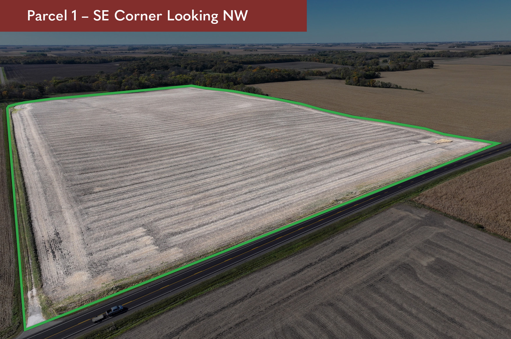


DESCRIPTION:
COM SE 1/4 COR N1317.82', W1321.96', W524.47', SE1312.29', E480.05', E1319.14' TO BEG Sec 8 and SW 1/4 SW 1/4 W of HWY 169 Sec 9 all in T101N-R27W
TAX ID #:
070080500, 070091000, 070090800
REAL ESTATE TAXES:
Estimated Ag Homestead Taxes - $1,926.00
Special Assessment - $0.00
Total Estimated Tax & Specials - $1,926.00
Taxes are estimates based on 2025 ag-homestead rates and are subject to change.
FSA INFORMATION:
Total Acres - 69.91± acres
FSA Tillable Acres - 66.50± acres
Corn Base Acres - 40.93± acres
Corn PLC Yield - 164.00± bushels
Soybean Base Acres - 26.23± acres
Soybean PLC Yield - 45.00± bushels
FSA tillable and base acres have been estimated based on survey and 156EZ.
Subject to change pending FSA reconstitution.
RENT/LEASE INFORMATION:
Farm is open to lease or farm for 2026 crop year.
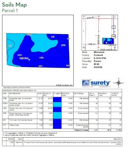
SOIL DESCRIPTION:
Ocheyedan loam, Webster clay loam, Coland clay loam, Terril loam. See Soils Map.
CROP PRODUCTIVITY INDEX (CPI):
89.4 CPI
TOPOGRAPHY:
Rolling
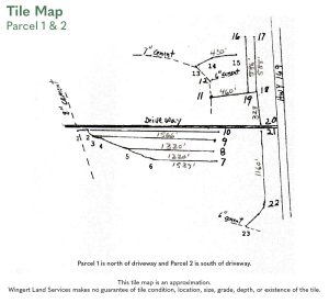
DRAINAGE:
Outlet to river to the west. See Tile Map.
CRP:
N/A
NRCS CLASSIFICATION ON TILLABLE ACRES:
PC/NW - Prior Converted/No Wetlands; NHEL - No Highly Erodible Lands;
HEL - Highly Erodible Lands
Other:
Parcel 1 is the grantee of a perpetual drainage and tile easement, with the parcel to the west, for the purposes of use, inspection, repair, maintenance, upgrade, replacement, and preservation of the Tile Line located on Grantor’s Property (the “Easement”). Such Easement shall include the right to replace the Tile Line with new drainage tile of a larger size or capacity.
Buyer of Parcel 1 will allow for a drainage agreement with the Buyer of Parcel 2, if different Buyers, for the repair, maintenance, and improvement of an existing tile main per the tile map “Parcel 1 & 2”.
The driveway located on Parcel 1 will remain as an access easement for the building site.
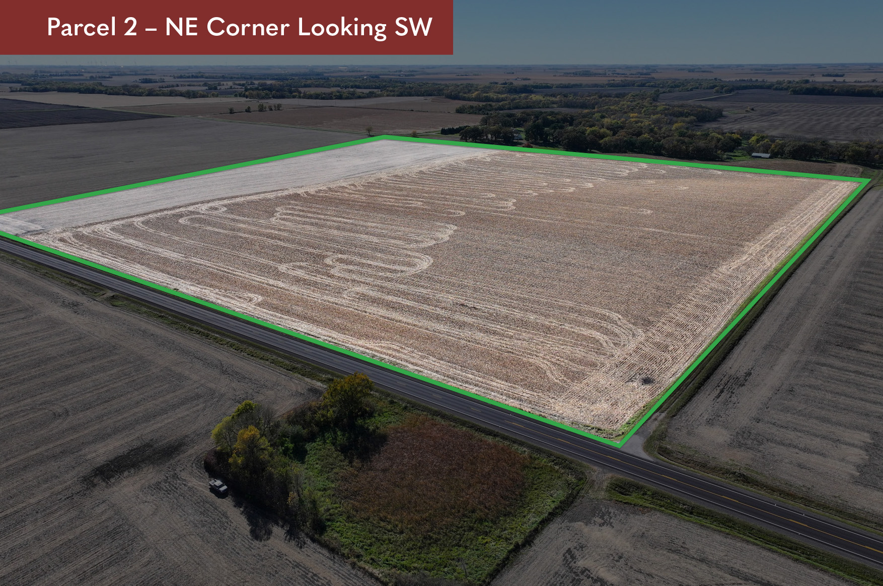
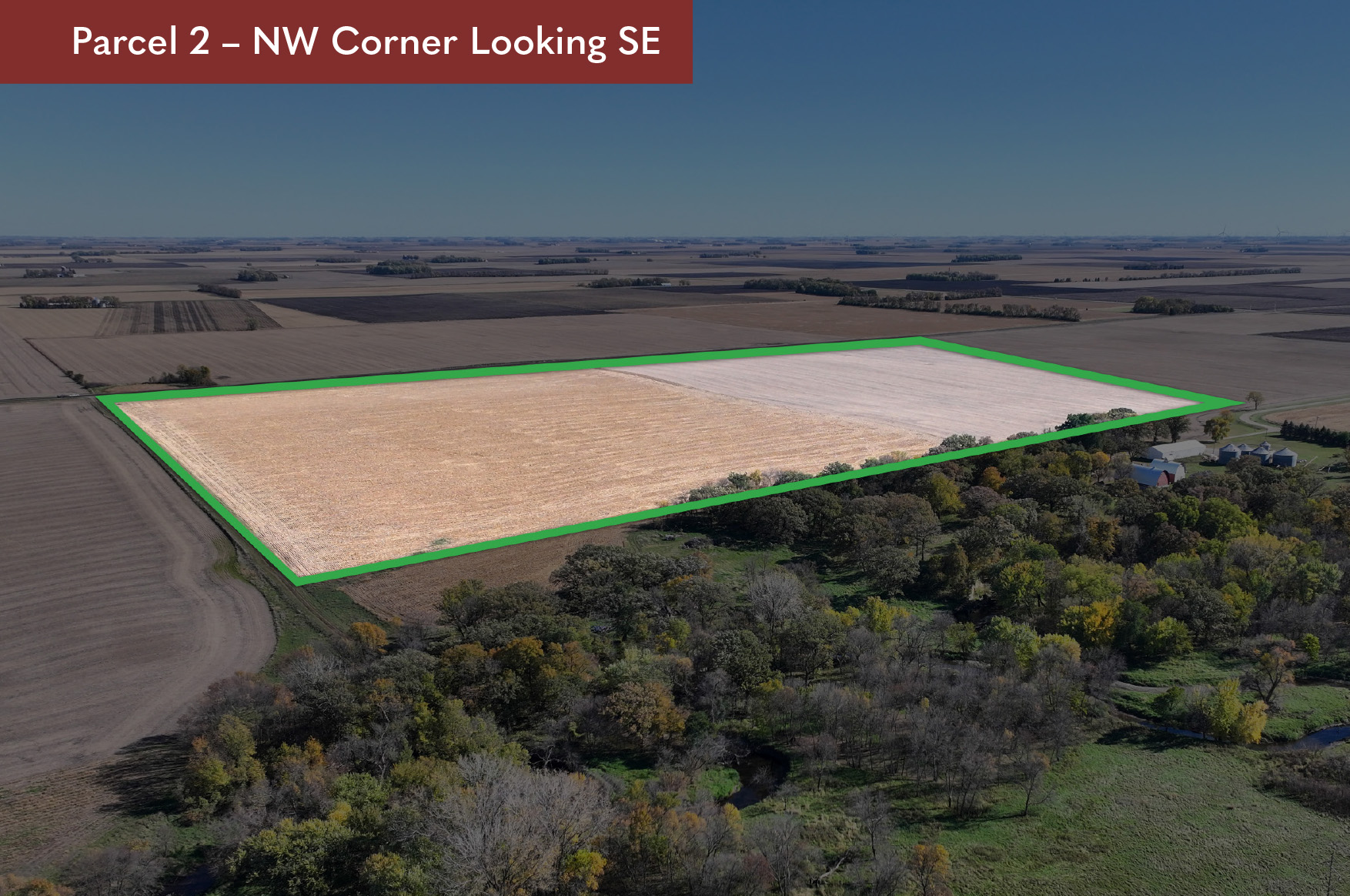
DESCRIPTION:
NE 1/4 of NE 1/4; EX COM SW CON of NE 1/4 of NE 1/4; N264.85', SE266.10', W25.00' TO BEG. (PART OF 07.017.0900 in NE 1/4 of NE 1/4) and part of the N 1/2 SE 1/4 NE 1/4 Sec 17 and NW 1/4 NW 1/4 west of HWY 169 Sec 16, all in T101N-R27W
TAX ID #:
070170800; 070160900, 070161100 (partial)
REAL ESTATE TAXES:
Estimated Ag Homestead Taxes - $1,411.68
Special Assessment - $259.27
Total Estimated Tax & Specials - $1,670.96
Taxes are only an estimation based on parcel split and 2025 ag-homestead rates and are subject to change.
FSA INFORMATION:
Total Acres - 82.81± acres
FSA Tillable Acres - 82.75± acres
Corn Base Acres - 50.30± acres
Corn PLC Yield - 164.00± bushels
Soybean Base Acres - 32.20± acres
Soybean PLC Yield - 45.00± bushels
Total deeded acres are estimated and subject to change.
FSA tillable and base acres have been estimated based on survey and 156EZ. Subject to change pending FSA reconstitution.
RENT/LEASE INFORMATION:
Farm is open to lease or farm for 2026 crop year.
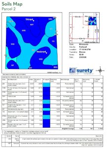
SOIL DESCRIPTION:
Waldorf silty clay loam, Truman silt loam, Ocheyedan loam, Fostoria loam, Okoboji silty clay loam, Kingston silty clay loam. See Soils Map.
CROP PRODUCTIVITY INDEX (CPI):
92.0 CPI
TOPOGRAPHY:
Level to gently rolling.
DRAINAGE:
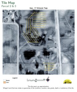
Private mains and laterals with outlet to CD-36 and river outlet. See Tile Map.
CRP:
N/A
NRCS CLASSIFICATION ON TILLABLE ACRES:
PC/NW - Prior Converted/No Wetlands; NHEL - No Highly Erodible Lands
OTHER:
Parcel 2 is the grantee of a perpetual drainage and tile easement, with the parcel to the west, for the purposes of use, inspection, repair, maintenance, upgrade, replacement, and preservation of the Tile Line located on Grantor’s Property (the “Easement”). Such Easement shall include the right to replace the Tile Line with new drainage tile of a larger size or capacity.
Buyer of Parcel 2 will enter into a drainage agreement with Buyer of Parcel 3 for maintenance and repair of existing tile lines if purchased by separate buyers.
Parcel 2 will be surveyed by Seller if purchased by different Buyer than Parcel 3.
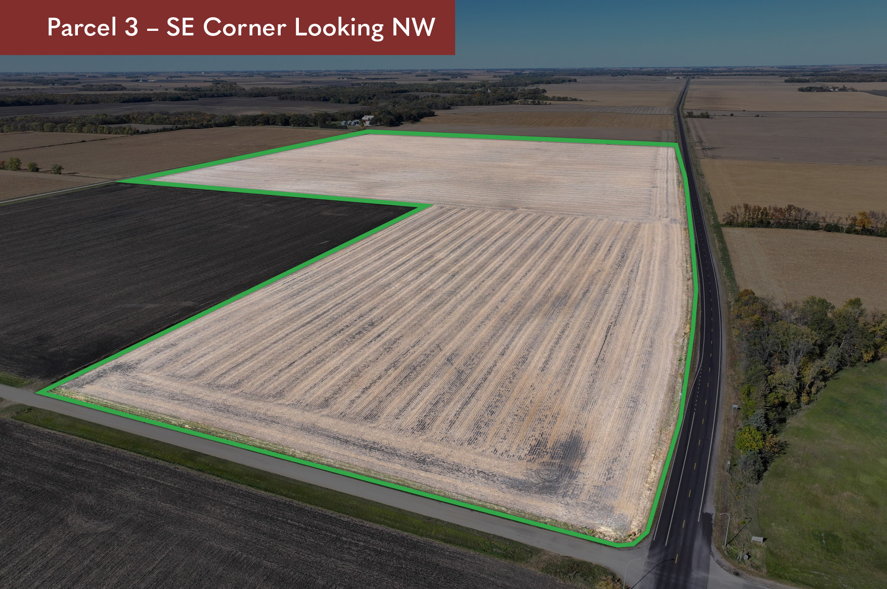
DESCRIPTION:
Part of SE 1/4 NE 1/4 & NE 1/4 SE 1/4 Sec 17 and that part of the SW 1/4 NW 1/4 laying west of former RR property and that part of the SW 1/4 SW 1/4 laying west of former RR property and that part of the former RR property in SW 1/4 NW 1/4 and that part of the former RR property in SW 1/4 SW 1/4 T101N-R27W (Survey Legal to Govern)
TAX ID #:
070170600 (Partial), 070160200 (Partial), 070161100 (Partial), 070161200, 070160100 (Partial)
REAL ESTATE TAXES:
Estimated Ag Homestead Taxes - $4,688.51
Special Assessment - $1,142.84
Total Estimated Tax & Specials - $5,831.35
Taxes are only an estimation based on parcel split and 2025 ag-homestead rates and are subject to change.
FSA INFORMATION:
Total Acres - 117.43± acres
FSA Tillable Acres - 114.89± acres
Corn Base Acres - 69.88± acres
Corn PLC Yield - 164.00± bushels
Soybean Base Acres - 44.77± acres
Soybean PLC Yield - 53.00± bushels
Total deeded acres are estimated and subject to change.
RENT/LEASE INFORMATION:
Farm is open to lease or farm for 2026 crop year.
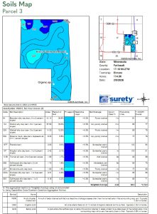
SOIL DESCRIPTION:
Brownton silty clay loam, Okoboji silty clay loam, Waldorf silty clay loam. See Soils Map.
CROP PRODUCTIVITY INDEX (CPI):
84.3 CPI
TOPOGRAPHY:
Level to gently rolling.
DRAINAGE:
Private mains and laterals with outlet to CD-30. See Tile Map.
CRP:
N/A
NRCS CLASSIFICATION ON TILLABLE ACRES:
PC/NW - Prior Converted/No Wetlands
NHEL - No Highly Erodible Lands
OTHER:
Parcel 3 will be surveyed if purchased by a different buyer than Parcel 2.
DESCRIPTION:
NW 1/4 SE 1/4 and tract commencing center corner of section; N720.35', E1320.68', S714.61', W1321.27' TO BEG
TAX ID #:
070170500
REAL ESTATE TAXES:
Estimated Ag Homestead Taxes - $1,706.20
Special Assessment - $515.80
Total Estimated Tax & Specials - $2,222.00
Taxes and special assessments are estimates based on 2025 ag-homestead rates and are subject to change.
FSA INFORMATION:
Total Acres - 61.59± acres
FSA Tillable Acres - 58.78± acres
Corn Base Acres - 35.75± acres
Corn PLC Yield - 164.00± bushels
Soybean Base Acres - 22.91± acres
Soybean PLC Yield - 63.00± bushels
RENT/LEASE INFORMATION:
Farm is open to lease or farm for 2026 crop year.
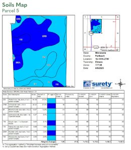
SOIL DESCRIPTION:
Waldorf silty clay loam, Truman silt loam, Ocheyedan loam. See Soils Map.
CROP PRODUCTIVITY INDEX (CPI):
90.0 CPI
TOPOGRAPHY:
Level
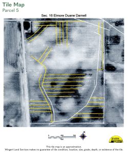
DRAINAGE:
Outlet to CD-36 with private mains and laterals.
CRP:
N/A
NRCS CLASSIFICATION ON TILLABLE ACRES:
PC/NW - Prior Converted/No Wetlands
NHEL - No Highly Erodible Lands
DESCRIPTION:
All of NW 1/4 E of HWY 169 Sect16-T101N-R27W
TAX ID #:
070160700
REAL ESTATE TAXES:
Estimated Ag Homestead Taxes - $5,741.78
Special Assessment - $466.22
Total Estimated Tax & Specials - $6,208.00
Taxes and special assessments are estimates based on 2025 ag-homestead rates and are subject to change.
FSA INFORMATION:
Total Acres - 117.94± acres
FSA Tillable Acres - 117.08± acres
Corn Base Acres - 70.00± acres
Corn PLC Yield - 164.00± bushels
Soybean Base Acres - 46.90± acres
Soybean PLC Yield - 53.00± bushels
RENT/LEASE INFORMATION:
Farm is open to lease or farm for 2026 crop year.
SOIL DESCRIPTION:
Waldorf silty clay loam, Ocheyedan loam, Brownton silty clay loam, Collinwood silty clay loam. See Soils Map.
CROP PRODUCTIVITY INDEX (CPI):
87.9 CPI
TOPOGRAPHY:
Level
DRAINAGE:
Private main and laterals with outlet to CD-36. See Tile Map.
CRP:
N/A
NRCS CLASSIFICATION ON TILLABLE ACRES:
PC/NW - Prior Converted/No Wetlands
NHEL - No Highly Erodible Lands
Wetland present
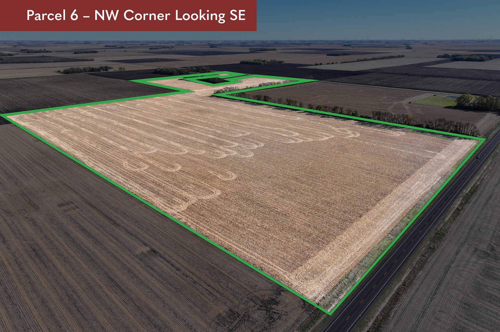
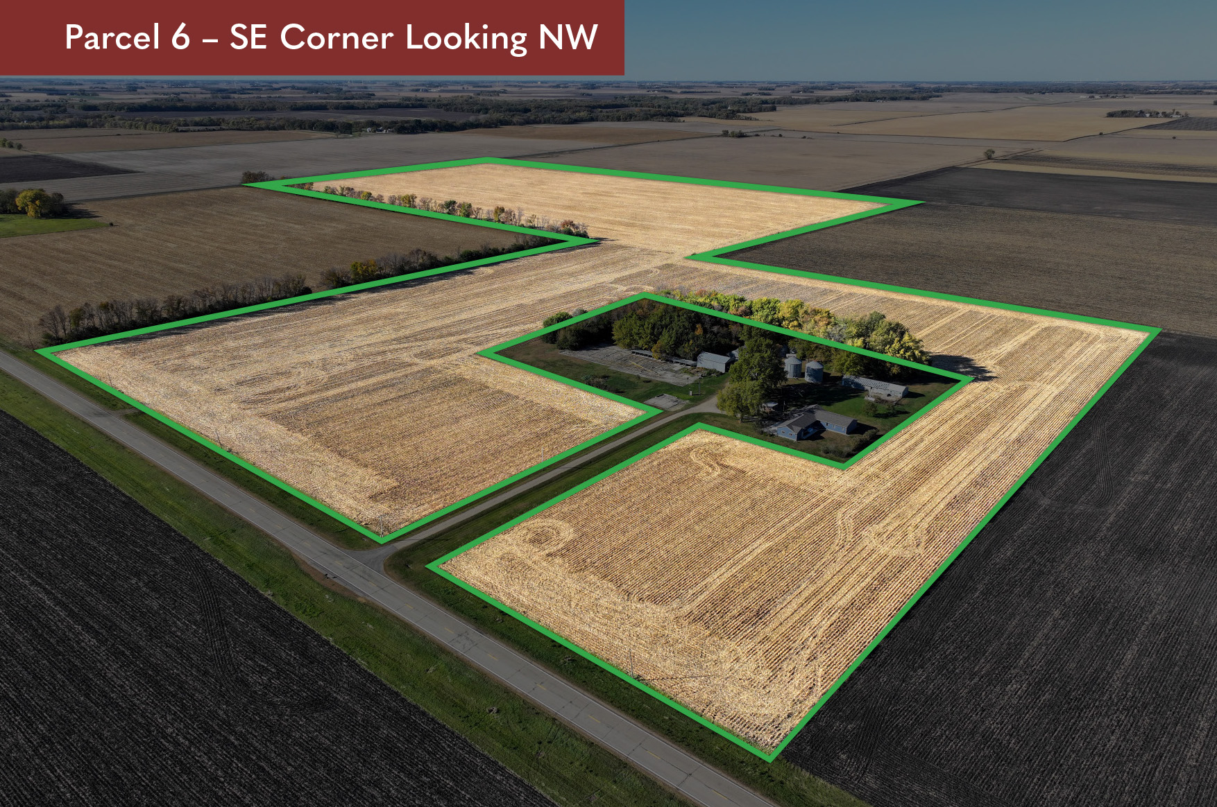
DESCRIPTION:
NE 1/4 of SW 1/4 & W22R of NW 1/4 of SE 1/4 & all that part of NW 1/4 of SW 1/4 LY E of RR R/W & SW 1/4 of SE 1/4 EX TR COM 911.86'E of SW COR SE 1/4 TH E48' N479' E180.14' N400' W 509' S400' E280.86' S479' TO BEG
TAX ID #:
070160801
REAL ESTATE TAXES:
Estimated Ag Homestead Taxes - $4,577.12
Special Assessment - $1,074.88
Total Estimated Tax & Specials - $5,652.00
Taxes and special assessments are estimates based on 2025 ag-homestead rates and are subject to change.
FSA INFORMATION:
Total Acres - 103.83± acres
FSA Tillable Acres - 97.82± acres
Corn Base Acres - 53.50± acres
Corn PLC Yield - 171.00± bushels
Soybean Base Acres - 44.00± acres
Soybean PLC Yield - 52.00± bushels
RENT/LEASE INFORMATION:
Farm is open to lease or farm for 2026 crop year.
SOIL DESCRIPTION:
Brownton silty clay loam, Waldorf silty clay loam, Marna silty clay loam, Okoboji silty clay loam. See Soils Map.
CROP PRODUCTIVITY INDEX (CPI):
85.0 CPI
TOPOGRAPHY:
Level
DRAINAGE:
Outlet to CD-36.
CRP:
N/A
NRCS CLASSIFICATION ON TILLABLE ACRES:
PC/NW - Prior Converted/No Wetlands
NHEL - No Highly Erodible Lands
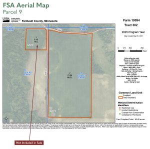
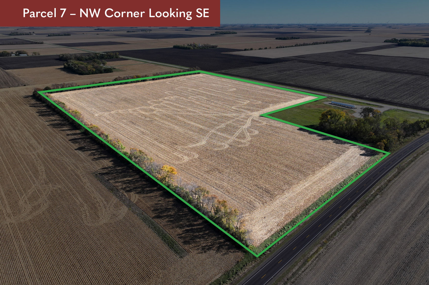
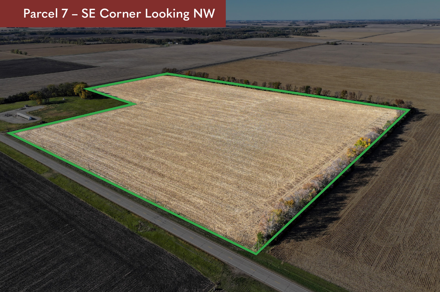
TAX ID #: 070160100
REAL ESTATE TAXES: Estimated Ag Homestead Taxes - $993.08 Special Assessment - $523.57 Total Estimated Tax & Specials - $1,516.65 Taxes and special assessments are estimates based on 2025 ag-homestead rates and are subject to change.
FSA INFORMATION: Total Acres - 45.00± acres FSA Tillable Acres - 44.54± acres Corn Base Acres - 28.40± acres Corn PLC Yield - 153.00± bushels Soybean Base Acres - 16.10± acres Soybean PLC Yield - 53.00± bushels
RENT/LEASE INFORMATION: Farm is open to lease or farm for 2026 crop year.
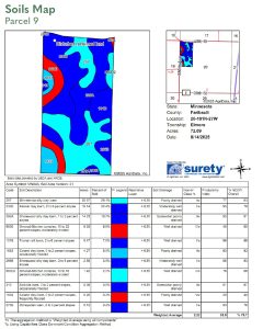
SOIL DESCRIPTION: Brownton silty clay loam, Okoboji silty clay loam, Ocheyedan loam, Crippin loam. See Soils Map.
CROP PRODUCTIVITY INDEX (CPI): 85.1 CPI
TOPOGRAPHY: Level
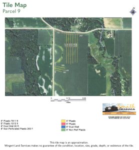
DRAINAGE: Private mains and laterals with outlet to CD-36. See Tile Map.
CRP: N/A
NRCS CLASSIFICATION ON TILLABLE ACRES: PC/NW - Prior Converted/No Wetlands NHEL - No Highly Erodible Lands
OTHER: Parcel 7 to be surveyed if sold to different Buyer than Parcel 3.
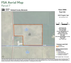
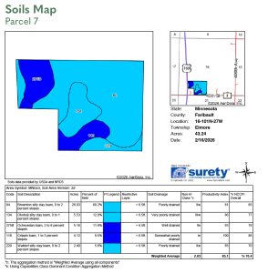
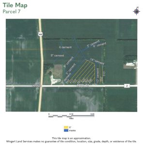
TAX ID #: 070211000
REAL ESTATE TAXES: Estimated Ag Homestead Taxes - $3,668.76 Special Assessment - $819.24 Total Estimated Tax & Specials - $4,488.00 Taxes and special assessments are estimates based on 2025 ag-homestead rates and are subject to change.
FSA INFORMATION: Total Acres - 74.53± acres FSA Tillable Acres - 72.62± acres Corn Base Acres - 46.70± acres Corn PLC Yield - 153.00± bushels Soybean Base Acres - 25.90± acres Soybean PLC Yield - 53.00± bushels
RENT/LEASE INFORMATION: Farm is open to lease or farm for 2026 crop year.
SOIL DESCRIPTION: Brownton silty clay loam, Waldorf silty clay loam, Nicollet clay loam, Clarion loam. See Soils Map.
CROP PRODUCTIVITY INDEX (CPI): 87.4 CPI
TOPOGRAPHY: Level
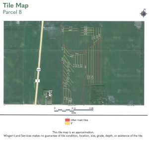
DRAINAGE: Private mains and laterals with outlet to CD-36. See Tile Map.
CRP: N/A
NRCS CLASSIFICATION ON TILLABLE ACRES: PC/NW - Prior Converted/No Wetlands NHEL - No Highly Erodible Lands
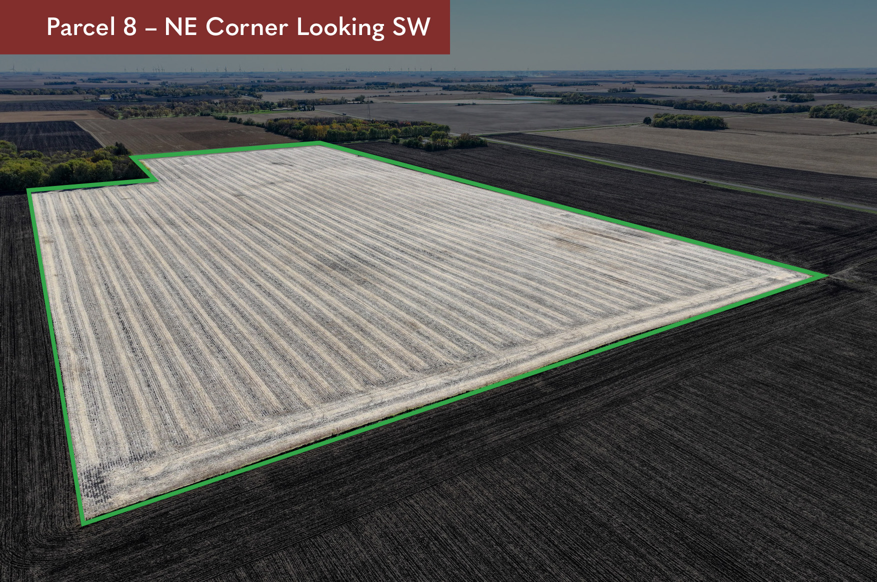
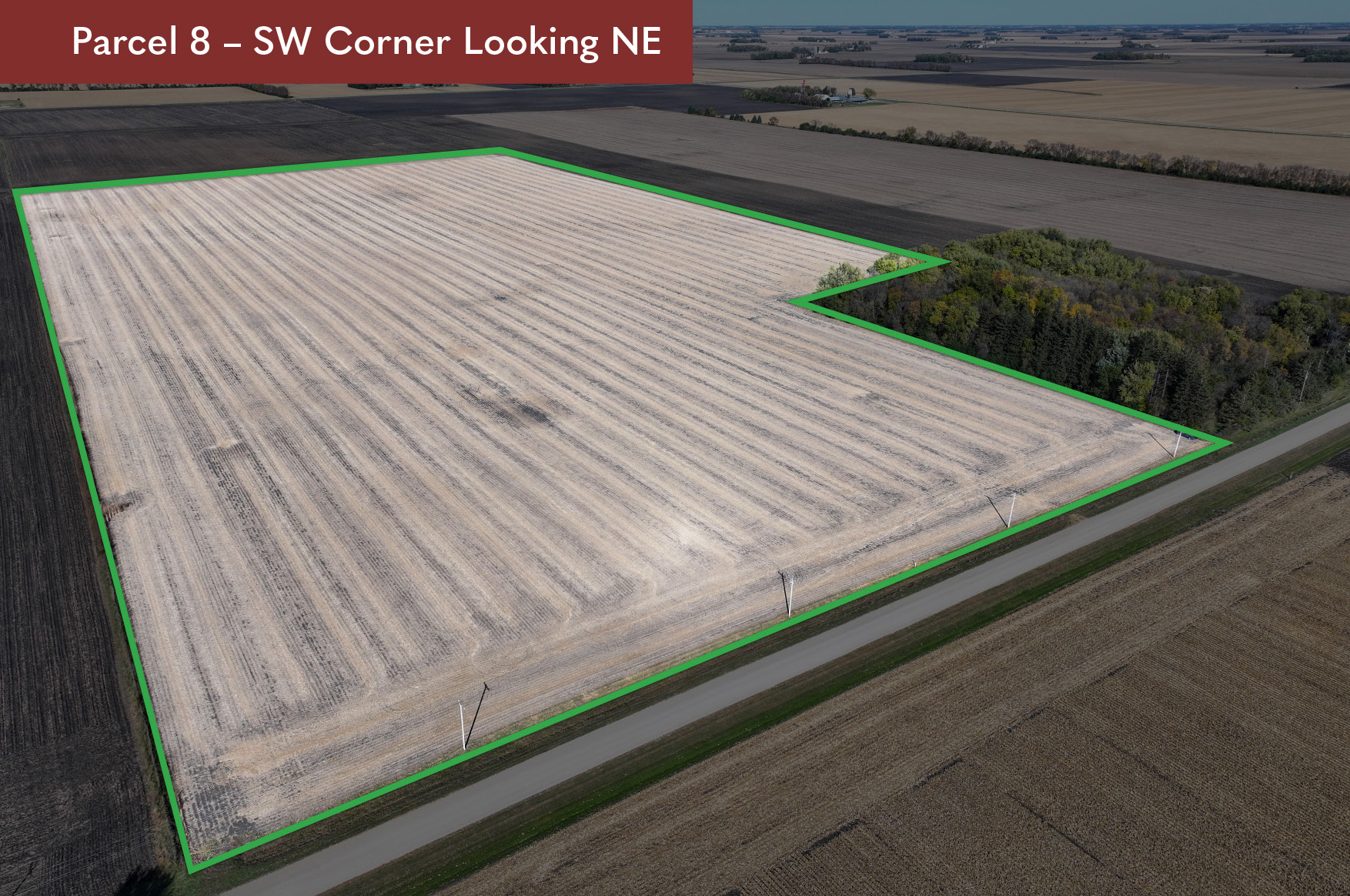
DESCRIPTION:
W 1/2 NW 1/4 exc. 2.5 ac north of road, Sec20-T101N-R27W
TAX ID #:
070200200
REAL ESTATE TAXES:
Estimated Ag Homestead Taxes - $1,856.00
Special Assessment - $0.00
Total Estimated Tax & Specials - $1,856.00
Taxes and special assessments are estimates based on 2025 ag-homestead rates and are subject to change.
FSA INFORMATION:
Total Acres - 77.50± acres
FSA Tillable Acres - 72.09± acres
Corn Base Acres - 43.60± acres
Corn PLC Yield - 153.00± bushels
Soybean Base Acres - 28.30± acres
Soybean PLC Yield - 53.00± bushels
FSA base acres are estimated pending reconstitution.
RENT/LEASE INFORMATION:
Farm is open to lease or farm for 2026 crop year.
SOIL DESCRIPTION:
Minnetonka silty clay loam, Kamrar clay loam, Shorewood silty clay loam. See Soils Map.
CROP PRODUCTIVITY INDEX (CPI):
83.9 CPI
TOPOGRAPHY:
Gently rolling.
DRAINAGE:
Private mains and laterals with outlet to CD-36. See Tile Map.
CRP:
N/A
NRCS CLASSIFICATION ON TILLABLE ACRES:
PC/NW - Prior Converted/No Wetlands
NHEL - No Highly Erodible Lands
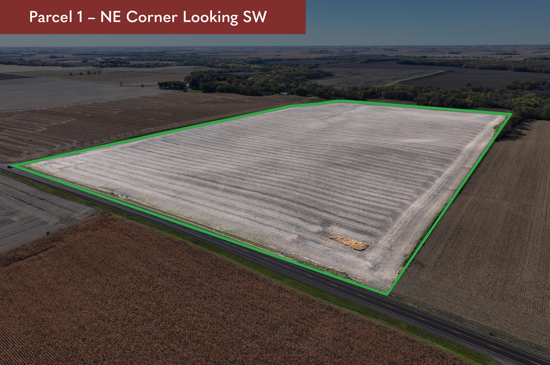
Parcel 1
Click to view larger image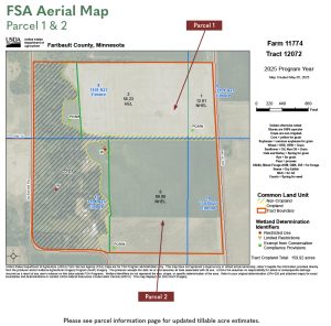
Parcel 2
Click to view larger image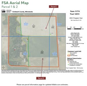
Parcel 3
Click to view larger image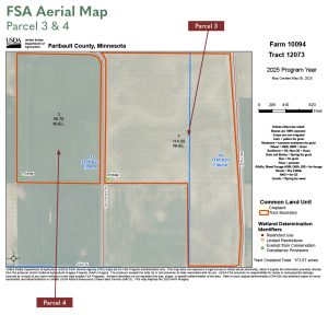
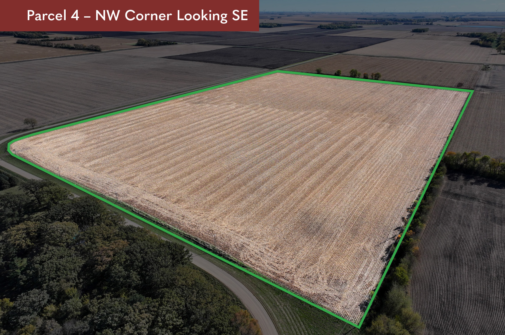
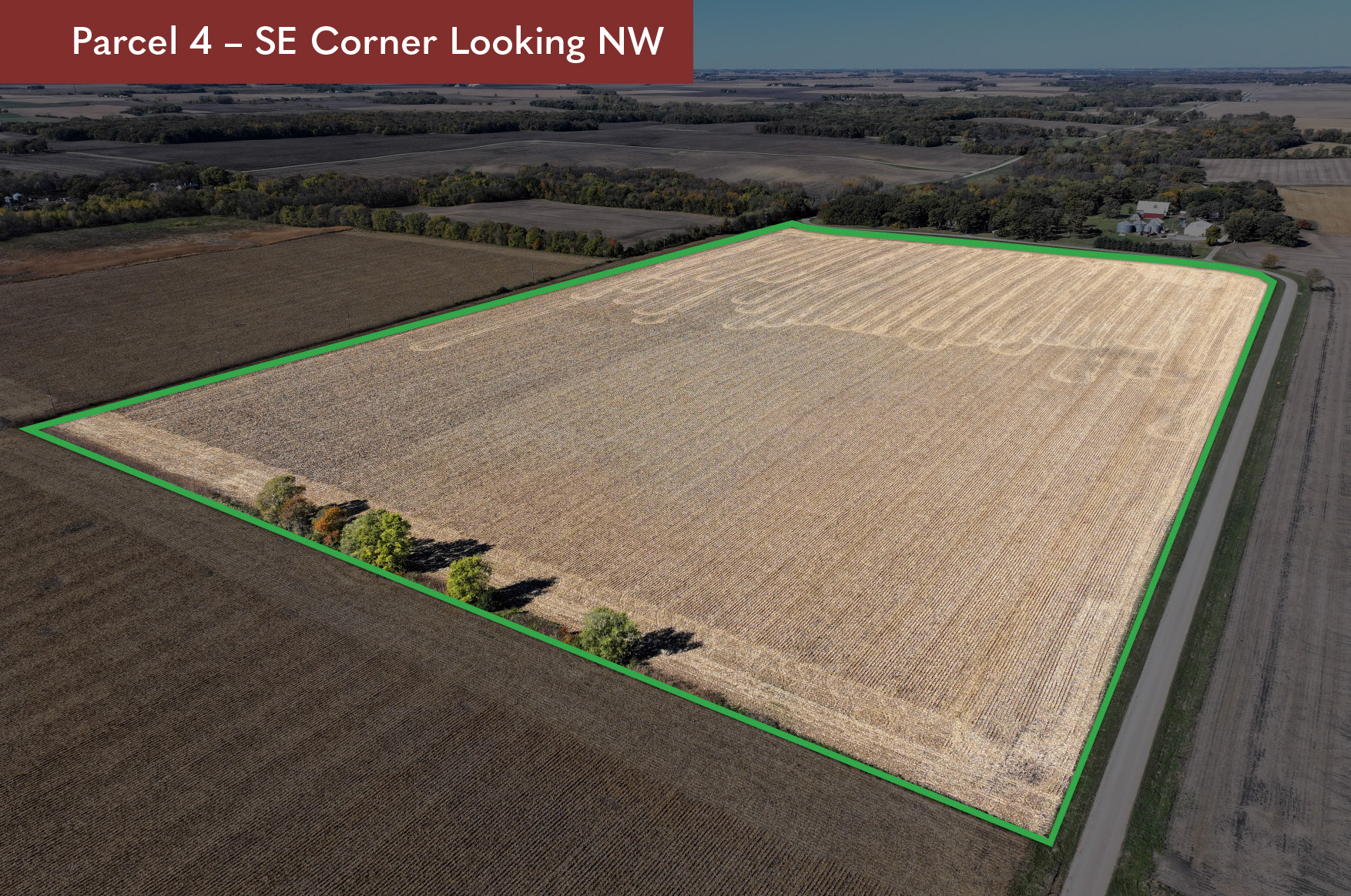
Parcel 4
Click to view larger image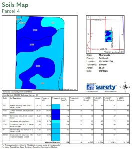
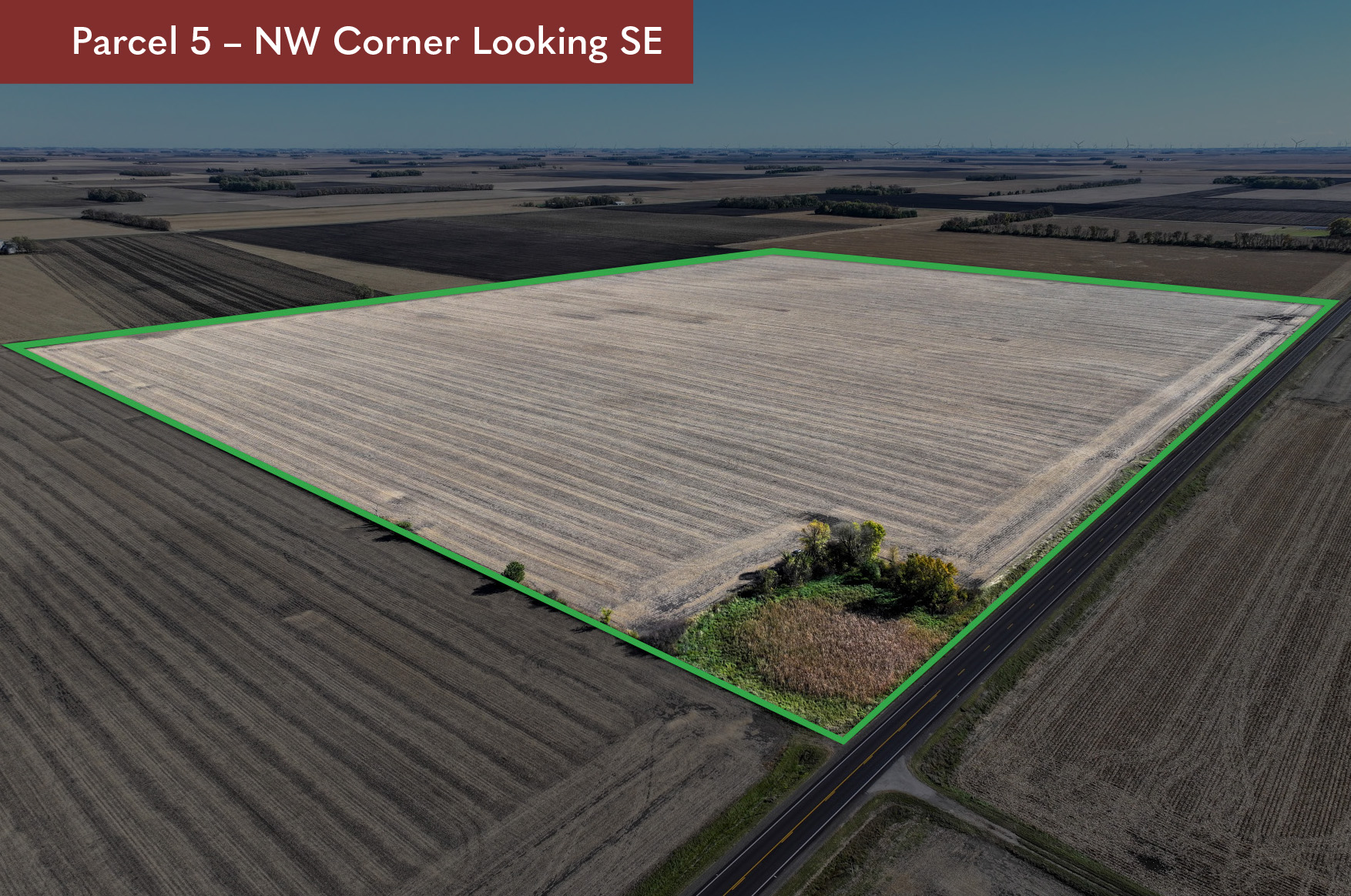
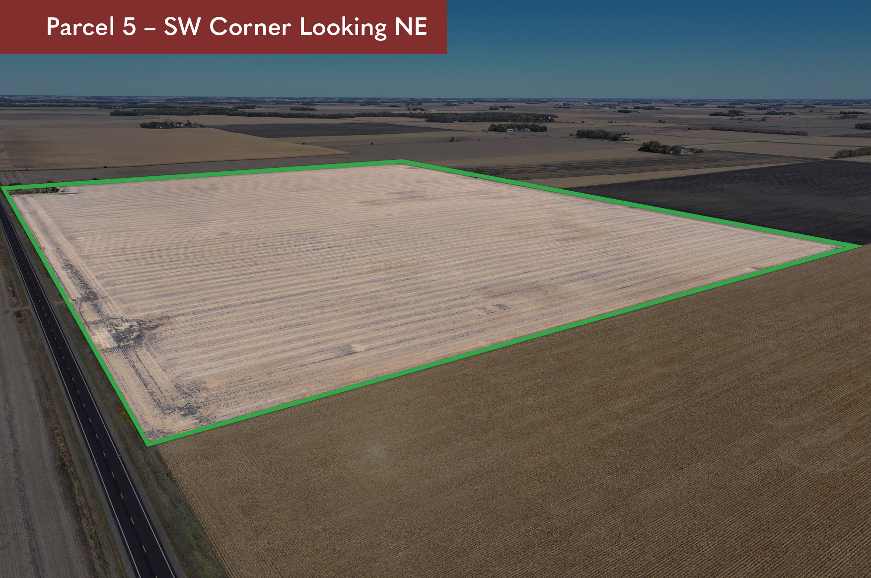
Parcel 5
Click to view larger image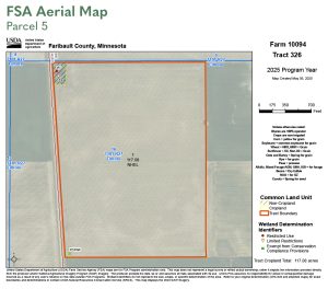
Parcel 6
Click to view larger image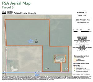

Parcel 7
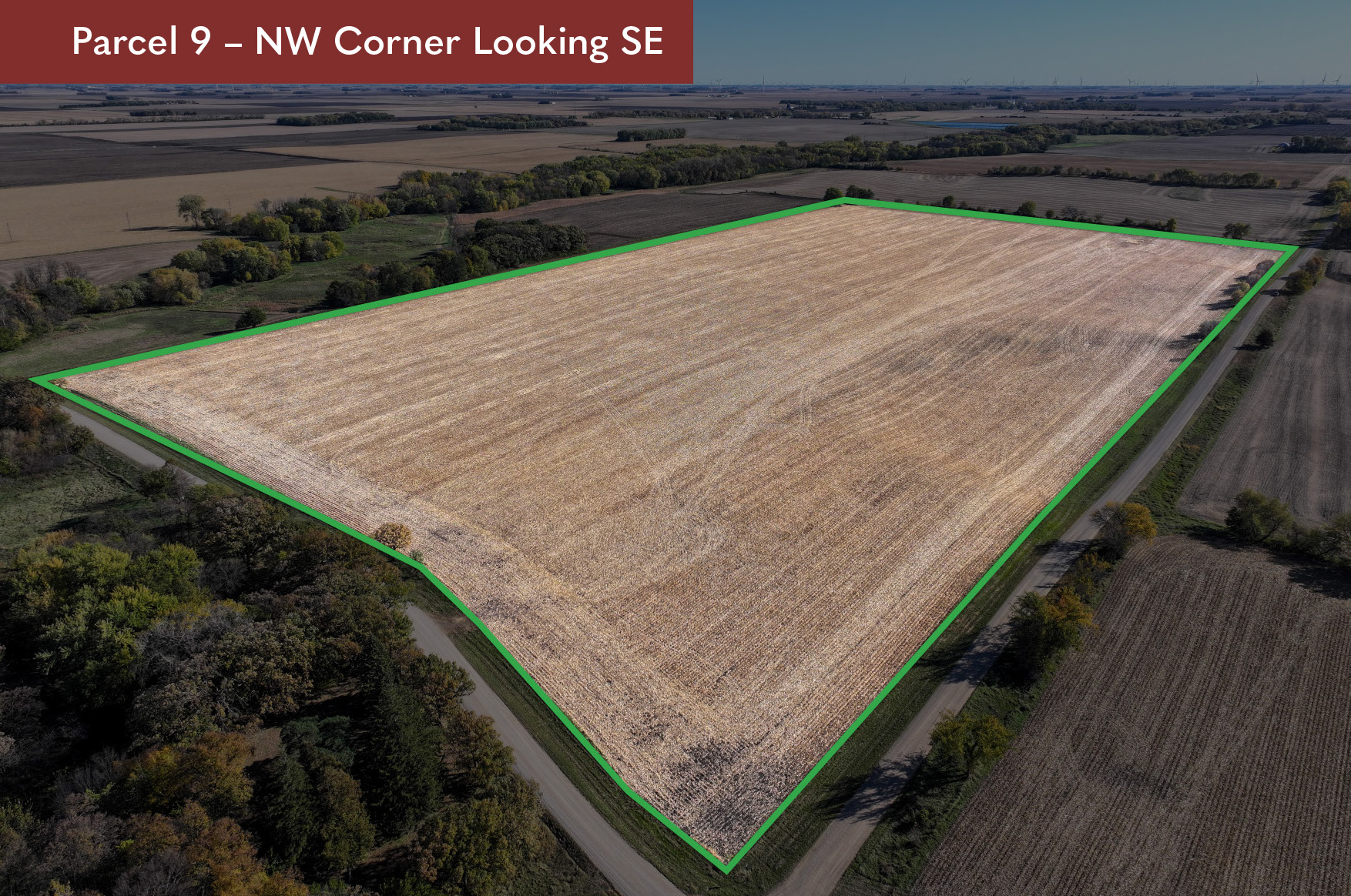
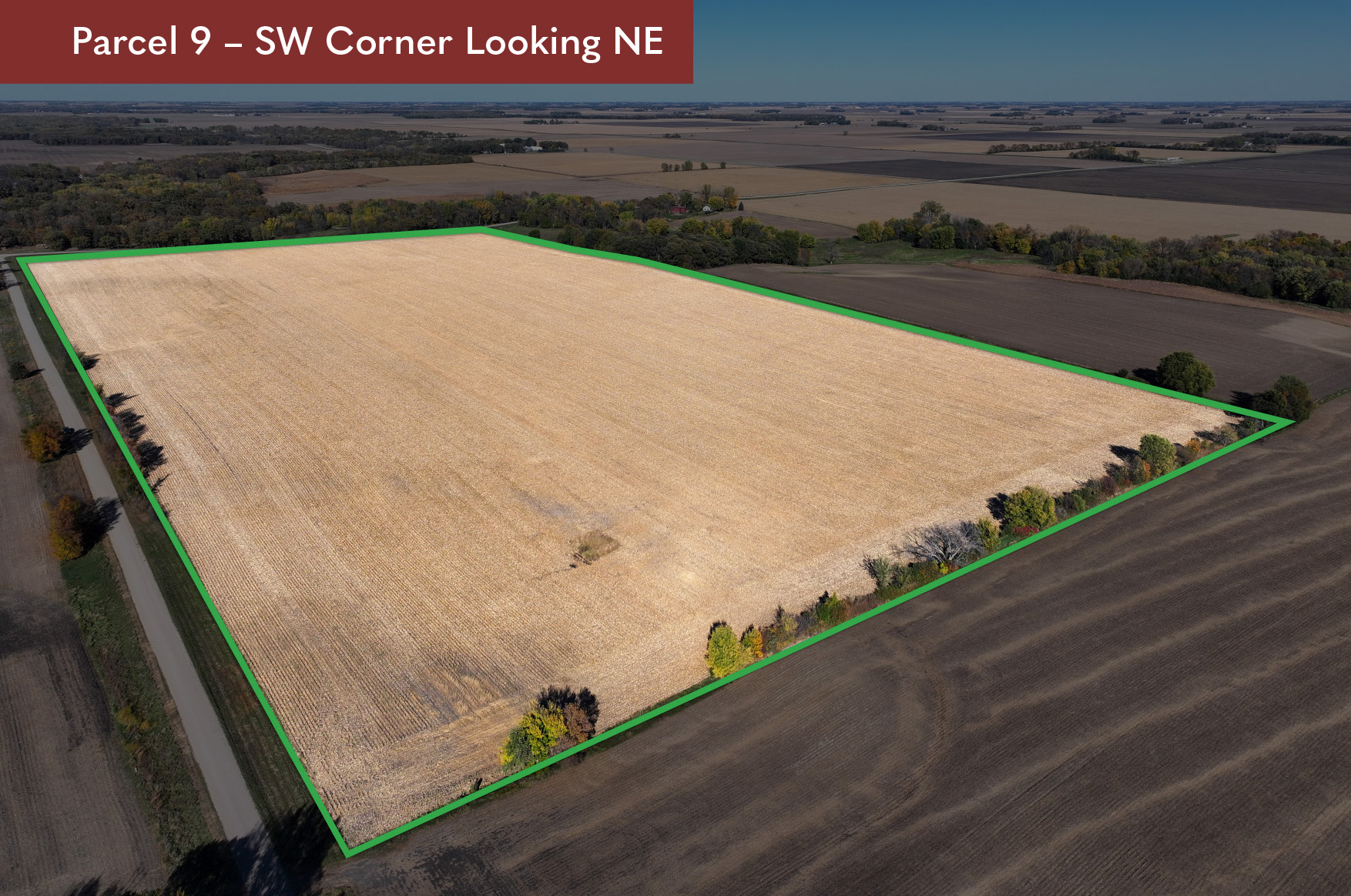
Parcel 8
Click to view larger image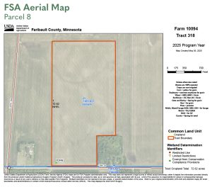

Parcel 9
Click to view larger image